History
- Details
- Category: Uncategorised
- Written by Super User
- Hits: 1945
HISTORY
By: Oswaldo T. Borja and Dick L. Edera
Dinagat is the oldest community in Dinagat Islands, situated northeast of the Province of Surigao del Norte and east of Leyte.
In the early days of its existence, the pueblo was given different names such as Kankayanit and Nantias which means, here, lived Kankayanit and Tias. It was also called Busay where waterfalls were found, and Panagatan, a tongue-shaped cove where the natives went fishing. During the months of June, July, August and September when “Habagat” rages, its fury would deter one from going out fishing at Panagatan and whoever goes out to the sea who becomes seasick will be referred to as “Gidagat” and “Indagat “ in Visayan.
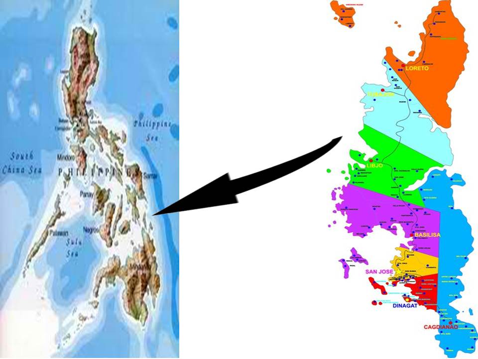
A story was told that a stranger reached the place in search of greener pastures. He approached a native and asked him what the inhabitants do for a living, and he answered that they farm and fish to live. His interest in fishing prompted him to inquire where they fish, and he replied and pointed to a place, saying in this native tongue, “dinhiniininadagat”, which when translated in English means, here, from this bountiful seawaters. The stranger thereafter called the place Dinagat. Since then and until now the name Dinagat has not changed. It has been the official name of the first and the oldest community in Dinagat Islands then composed of the six (6) sitios of Busay, Pangi, Masikop, Masi-od, Balinao-nao andCan-ondo, and is still the official name of the mother Municipality of the six (6) towns of Loreto, Tubajon, Libjo (Albor),Basilisa (Rizal), Cagdianao and San Jose, having a total land area of 3,073.48 hectares only, and twelve (12) barangays.
Dinagat was originally inhabited by people from the neighboring provinces of Bohol and Leyte. The first settlers came from Leyte. The generous Leyteños informed some Boholanos traders of a fertile land east of Leyte. The Boholanos, adventurous as they were and still are, set their course taking the southward direction and arrived at Dinagat in the early part of 1800. They found the seawaters of Dinagat abundant with fish in its clear, blue waters and rich marine life. Truly, the land of Dinagat was fertile, what with its virgin forest, verdant hills and mountains where nature’s bounties encouraged them to engage in fishing and farming as their chief means of livelihood. The early inhabitants/settlers were the families of Ventura, Ecunar, Ga and Gealogo, followed in 1825, by the families of Jarligo, Geraldino, Ensomo, Eviota and Gier.
The early part of 1830 marked the establishment of Dinagat as part of the Spanish Pueblo of Surigao. The economic growth of Dinagat had gradually improved and its population had increased prompting a Spanish priest to recommend to the higher Spanish authorities between the years 1840 and 1845 the conversion of Dinagat into a separated pueblo.
In 1849, one Angelo Faxon, a clerk from the Spanish pueblo of Surigao was sent to Dinagat to make a survey of the economic conditions of the inhabitants and he found them financially insufficient and unable to pay their taxes, but in kinds only like root crops and other farm products. They were encouraged to improve their lot in life and the place where they lived.
On September 1845, the provincial officials of Surigao headed by Alcalde Mayor Luis Ybañez Garcia after knowing that the settlers had considerably improved economically, and were more than capable of paying their taxes passed a resolution and issued Section de Gobierno No. 36 requesting Governor General Manuel Crespo for the separation of Dinagat from the mother pueblo of Surigao, with an independent parish. On January 23, 1855 Bishop Romualdo de Caraga favorably endorsed said request so that on April 25, 1855 Governor General Crespo issued Dirrecion General No. 5505 Leg. 103 which created Dinagat as the first Spanish pueblo and the first Catholic parish in Dinagat Island comprising the barangays of Libjo, Loreto, Tubajon, and Cagdianao.
The first set of municipal officials who served office during the period from 1855 to 1856 were: Gobernadorcillo – Pedro Ga Ventura; Los Principles – Marcos Jarligo, SereloEviota, Alejandro Geraldino, Leon Ga Ventura, LazaroGealogo, Juan Ensomo, and Miguel Gier.
During Spanish times, Dinagat suffered the attacks of the Muslims who pillaged the Christian towns in retaliation of the Spanish invasion of their territory. The Dinagatnons to protect themselves from the lookout spotted Moro Vintas. The ringing could be heard at distant sitios during fair weather. The bell warned the women and children to hide in the convent while the men armed themselves against the pirates.
In 1860, when the government throughout Mindanao Region was reorganized into six Politico Military Districts, the whole Island of Dinagat was annexed to Surigao District, which comprised as the third, or East District of Caraga. During this period, the ancient Island of Dinagat including all coastal territory were under the influence of the Spanish government.
In 1879, BarangayMabua of Dinagat was occasionally visited by the Parish Priest then assigned in Dinagat. Mabua was divided into six sections or barrios, but was still under the jurisdiction of Dinagat. By 1881, the name Mabua was changed to Loreto, the name was given by the Spanish Priest in honor of Loreto, the wife of the Alcalde Mayor of the Province of Surigao.
On September 4, 1890, the Governor General Manuel Sanches issued Direccion General No. 30 which created Loreto as the second Spanish Pueblo in Dinagat Island. The first set of Municipal Officials who served into Office were: Gobernadorcillo – Agustin Gupana; Los Principales – Trinidad Ga, Juan Esme, Francisco Cunales, Adriano Maquinano, LaurianoLulab, Petra Cuadra, PaulinoLuib and SeverinoLongino. New changes were brought about- aside from the old cedula taxes, land and internal revenue taxes were collected, and the Local Government was reorganized. The head of the community was no longer the Capitan but the Teniente del Barrio. By the end of Spanish rule in 1898, all Spanish citizens vacated the district, and the government was controlled by the native officers who sympathized during the revolution. Shortly thereafter, the United States military took over Surigao’s Administration, until Civil Government was restored in the Province on May 15, 1901.
On December 20, 1918, Governor General Francis Burton Harrison issued Executive Order No. 60 creating again Municipality of Loreto in the Province of Surigao. The Municipal President who served office during the period from 1919 to 1922 was Constantine Gupana.
Upon the recommendation by the Provincial Board of Surigao based upon Resolution No. 63, of the Municipal Council of Dinagat headed by Mayor Prospero E. Borja, Cagdianao was created as a municipality by virtue of Executive Order No.367 issued on December 23, 1959 by the Late President of Philippines, Carlos P. Garcia. The barrios of Cagdianao, Maatas, Bayantian, Cabungaan, Lahi, Santa Rita, Nueva Strella, Valencia, Boa and Tigbao, together with their respective sitios of Legaspi and Tapahan, all of the Municipality of Dinagat, Surigao are segregated from said municipality and organized into an independent municipality to be known as the Municipality of Cagdianao with the seat of government at the Barrio of Cagdianao. The first Municipal Mayor who served office during the period from 1960 to 1963 was Prospero E. Borja.
On December 2, 1959, the two Municipal Councils of Dinagat and Loreto held a joint session at Barrio Libjo. They unanimously approved Resolution No. 5, series of 1959, creating the Municipality of Albor in the Province of Surigao. It was agreed by the two councils that Loreto and Dinagat will contribute portions of their territories to comprise the new municipality. The Northern portion of the Municipality was part of Loreto, namely, Barrio Quezon, Libjo, Bolodbolod and San Jose. The Southern portion of the Municipality, such as Barrio Osmeña, Cahayag, Arellano and Plaridel were part of the Municipality of Dinagat.
LOCATION
The geographic positions of the four (4) outermost points of the Island Province are shown in Table 1.1 and Plate 1.1, along with its longitude and latitude.
Dinagat Islands is bounded on the north, starting from desolation point, by Surigao Strait; on the east by the Philippine Sea; on the south-east by Dinagat sound; on the south by Gaboc Channel and Nonoc Island; on the south-west by Awasan Bay, Hanigad Island and Hikdop Island; and on the west by Surigao Strait.
TABLE 1.1
Geographic Coordinates
|
SELECTED OUTERMOST POINTS |
LATITUDE |
LONGITUDE |
REMARKS |
|
Northernmost point |
10˚28’15.6173” |
125˚42’23.5890” |
Desolation Point |
|
Easternmost point |
9˚53’37.1657” |
125˚42’20.3417 |
Along Dinagat Sound |
|
Southernmost point |
9°51’12.0722” |
125°39’51.1642” |
Along Gaboc Channel |
|
Westernmost point |
10°08’14.3014” |
125°28’16.6544” |
Tungo Point |
| Source: Republic Act 9355 (Charter of the Province of Dinagat Islands) | |||
Plate 1. 1
Map of the Province of Dinagat Islands